Avalanche Education, Snow Safety, and the State of Backcountry Skiing, Winter 2022-2023
The skier triggered a slide on wind drifted snow above 10,000 feet on Utah’s famous Mt. Baldy, roughly eight inches deep and 25 feet across. They weren’t caught or injured, but nor were they expecting it. And why would they be? It was October 24, 2022, and it might’ve been the first recorded avalanche of the 2022-2023 season.
As winter hits its stride in the Northern Hemisphere, the lure of the backcountry has never been stronger. With a steady stream of stories chronicling “apocalyptic” lift lines at oversold resorts, an enduring COVID-induced spike in year-round outdoor recreation, and a continuing years-long boom in backcountry skiing and splitboarding, there’s potential for unprecedented interest in skipping the lift this winter.
As more people head into the backcountry—and by definition, more new users leave the gates—snow safety has never been more important and avalanche training, tools, and gear are top of mind for everyone involved in backcountry winter recreation.
onX Backcountry decided to take a look at stats from around the country gathered during the last few ski seasons, as well as a survey of over 100 backcountry skiers and boarders conducted during the 2021-2022 season, to present a look at the state of avalanche safety.
An onX Backcountry Survey
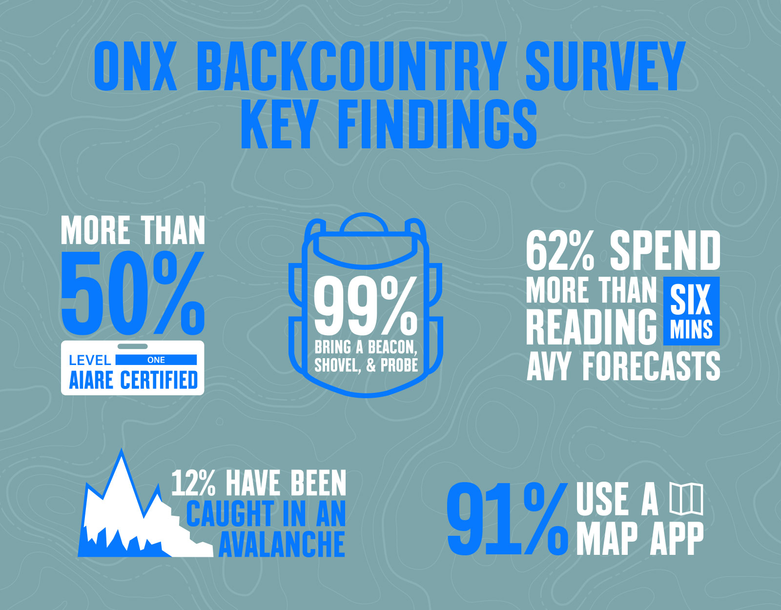
Last winter, onX Backcountry asked the backcountry skiing and splitboarding community for some perspective on avalanche education, snow safety, and how and with whom they recreate. We found respondents put a premium on formal training like AIARE 1 courses, nearly always carry the backcountry travel trinity of equipment with a beacon, probe, and shovel, and check avalanche forecasts religiously.
Key Findings
- 12% of respondents have been caught in at least one avalanche themselves.
- More than half of respondents have Level 1 education from the American Institute for Avalanche Research and Education (AIARE) and/or the American Avalanche Institute (AAI).
- Radios are more likely to be in a pack than an airbag, but the trifecta of a beacon, probe, and shovel will almost certainly be there.
- Backcountry users spend quality time with avalanche forecasts: nearly 90% check them every time they head into the backcountry and 60% spend more than six minutes examining them.
- 91% of respondents use an app like onX Backcountry when they’re skiing, snowboarding, or snowmobiling out of bounds.
2021-2022 Winter Recap
After the tragic winter of 2020-2021, when the backcountry claimed nearly 40 lives in the U.S., last season was a considerable change with less than half as many backcountry recreators killed as the previous season. This was in spite of some unique winter weather that saddled some of the most popular winter destinations in the country with a mid-season drought followed by spring storms that both recharged the snowpack and left dangerous conditions in their wake.
Overall, there were 17 fatalities reported by the Colorado Avalanche Information Center’s (CAIC) annual look at avalanche fatalities across the U.S., with six skiers and splitboarders, six snowmobilers, four snowshoers/hikers/climbers, and one “backcountry tourer” killed in an avalanche during the season, the lowest nationwide total since the winter of 2016-2017. None of those users were killed in an in-bounds incident.
Those incidents were also confined to a few Western states and Alaska, with six deadly slides in Colorado, three in Montana, two in Wyoming and one each in Idaho, Washington, and Alaska.
Utah, a front- and backcountry mecca, reported zero fatalities for the third time in four years, according to the Utah Avalanche Center’s annual report.
COVID, Crowding, and a Fundamental Shift
One of the unanticipated effects of the global COVID-19 pandemic that exploded in 2020 has been a sharp increase in participation of nearly every form of outdoor recreation. From hunting to cycling to hiking to backcountry skiing and splitboarding, an unprecedented shift in how Americans spend their leisure time has affected formerly somewhat niche activities.
The National Ski Areas Association (NSAA) reported the winter of 21-22 as having the highest-ever skier numbers at resorts, topping 60 million for only the third time ever. This on the heels of the 20-21 winter, which recorded the sixth-highest number of resort skiers ever. For comparison, the last pre-COVID winter, that of 2019-2020, clocked only the 34th-most resort skier visits since 1978.
That record visitation didn’t just arrive in the form of cold hard stats—longtime skiers also reported unprecedented lines, crowding, and frustrations as new and returning participants flocked to in-bounds options. As a result of the increased interest, both new and experienced backcountry skiers turned their backs on the lifts and sought out untracked turns in the backcountry.
That pandemic turbo-charge builds on an already rapidly expanding sector, as backcountry skiing had already grown by eight-fold in the 20 years between 1995 and 2019, according to one study. That growth corresponds to a steep jump in avalanche fatalities in the mid-90s that’s generally persisted to the present day with between 25-35 fatalities per year, according to CAIC, though continuing participation growth hasn’t delivered a correlated rise in backcountry deaths.
COVID-Fueled Explosion in Backcountry Interest
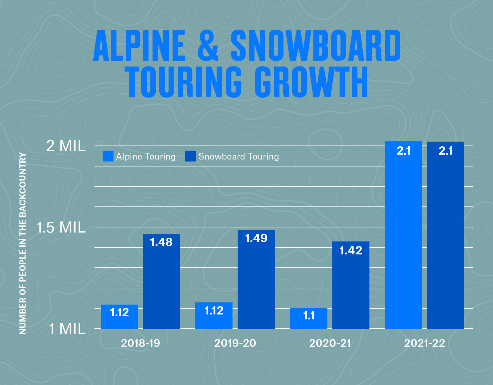
According to the Snowsports Industries America’s (SIA) Annual Participation Survey, the winter of ‘21-’22 has no peer when it comes to backcountry participation growth. Looking back to the winter of ‘18-’19, “Alpine Touring” and “Snowboard Touring” had jumped an impressive 12.5% and 9.6%, respectively (compare that to alpine skiing and snowboarding, which grew at 1.1% and 9.4% each from the year before). After a year of flat growth the next season, backcountry usage even contracted slightly during the first full COVID winter of ‘20-’21.
Then came last winter.
SIA estimates there were 2.15 million skiers out touring—an increase of 96% year over year—and 2.14 million splitboarders touring—50% higher than the previous year— and by far the biggest numbers ever recorded by the industry association.
Who’s In The Backcountry? New Arrivals and Experienced Vets.
As backcountry skiing and splitboarding grow in popularity, the mix of longtime, experienced backcountry travelers and new participants represents a range of users in spaces that are not just connected in geography, but oftentimes within groups moving through those spaces. In short, no matter whether this season is your first outside the ropes or your 30th, you’re connected by the slopes you travel and the people you recreate with.
onX Backcountry Survey Insights
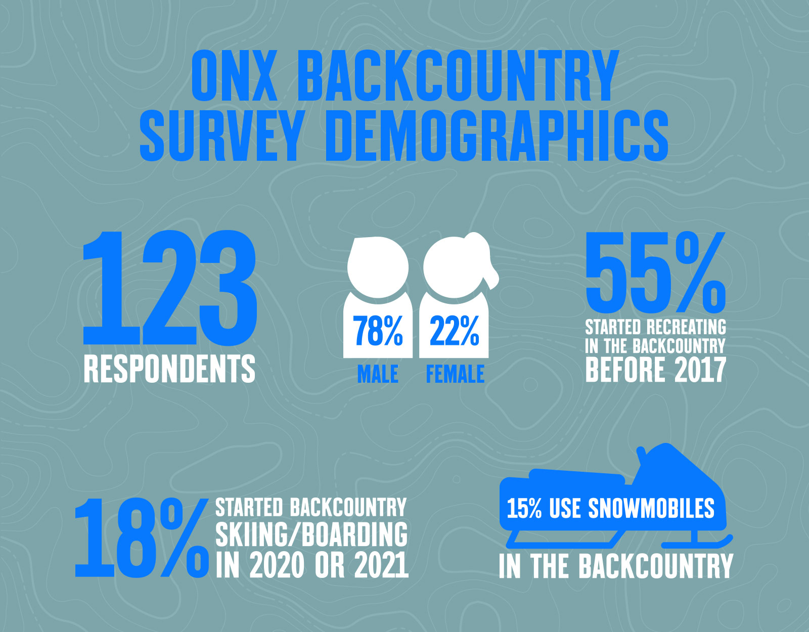
onX Backcountry’s survey was open to respondents who identified as current backcountry skiers and snowboarders—not folks who only aspire to earn their turns—and more than half (55%) started in the backcountry prior to 2017. The group ranged in skill level from beginner backcountry enthusiasts all the way through to professionals like a few ski patrollers and snow science students. The more than 100 people who responded to the survey displayed a range of risk tolerance, years of experience, and frequency of trips into the backcountry during the snow season.
Our respondents were 78% male and 22% female, a slightly higher proportion of men than on-resort skiers reported by the National Ski Area Association’s demographics data from the previous winter (a 63/37 split), and more than half between the ages of 25 and 44, hewing closely to the NSAA’s on-resort data that shows a median age of 35.
As for those who have actually been caught in an avalanche on their adventures? Twelve percent of survey respondents reported having been caught in a slide in the backcountry and 3% said they’d been caught in more than one. (Fifteen percent of respondents also use snowmobiles in the backcountry, but our data did not specify whether those caught in avalanches were traveling on snow machines or via human-powered means.)
Additional Survey Data
A new peer-reviewed study of more than 5,000 self-identified backcountry skiers published in October 2022 in the Wilderness & Environmental Medicine (WEM) journal corroborated the steep rise in winter backcountry usage reported by other industry groups and mainstream media. “Perceptions Among Backcountry Skiers During the COVID-19 Pandemic: Avalanche Safety and Backcountry Habits of New and Established Skiers” further identified that while COVID itself might not have pressured users into the backcountry, in-bounds resort closures and access issues were a major factor in pointing them toward new opportunities beyond the gates.
The WEM study results highlighted a shift toward the backcountry for nearly one fifth of respondents (19%) who reported spending 95%+ of their time on skis/boards in the backcountry vs. only 8% pre-COVID. The study also reported that experienced skiers were unlikely to change their habits in the backcountry with 97% reporting skiing with the same number of partners as pre-pandemic and none reporting a difference in distance toured from the trailhead. Though their habits in the backcountry might not have changed much, 30% of experienced backcountry skiers did report going into the backcountry more frequently.
Avalanche Education and Snow Safety
As participation in backcountry travel has skyrocketed, there are diverging data points regarding the level of backcountry preparedness among those venturing into uncontrolled (and un-patrolled) terrain. While our onX Backcountry survey showcased an extremely high level of education and adherence to best practices, other survey data shows new backcountry users venturing out with less formal avalanche training.
And all these studies feature an element of self-selection due to their promotion by avalanche training organizations and avalanche centers—reasonably implying that under-educated users are underreported in these datasets.
onX Survey Respondents Overwhelmingly Get Training
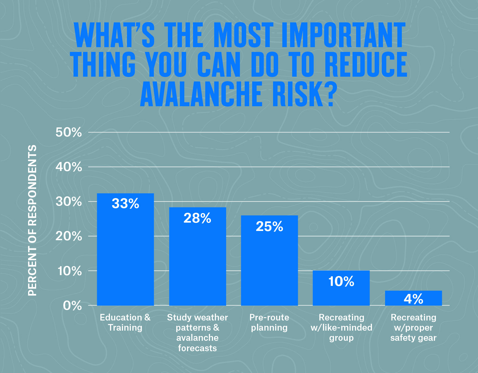
More than any specific slope angle, snow condition, group dynamic, or storm forecast, onX Backcountry survey respondents pointed to education as the single most important thing a backcountry user can have to stay safe in the snow. By learning what terrain to avoid, how to read a forecast, and how to have hard conversations with partners, you can make better decisions in the backcountry.
Both AIARE and AAI offer multiple levels of coursework, and a whopping 73% of onX Backcountry survey respondents said they’d completed a “Level 1” course from one of the two organizations (with two-thirds of those coming from AIARE). Another 12% reported completing Level 2 courses from one of the two avalanche organizations. The main differentiator between the two is that a Level 1 focuses on terrain management and hazard recognition while the Level 2 involves more snow science and avalanche forecasting, according to WildSnow.
The Challenge of Reaching New Riders
As noted above, surveys seeking self-identified backcountry skiers and riders are inherently challenged by the difficulty of reaching users who may not yet see themselves as full-fledged members of the backcountry community. The WEM study specifically sought out new backcountry users via ski areas and retailers, but despite those efforts some 70% of the organization’s respondents still came in via avalanche organizations (thus likely biasing toward users already checking reports, for example).
With that caveat in place, the WEM survey broadly found that the cohort of newcomers had a less-nuanced view of avalanche conditions and terrain, less formal avalanche education, and a lower self-reported backcountry skiing ability than their established backcountry compatriots.
Nearly a quarter (24%) of the new user cohort in the WEM lacked any formal backcountry training, according to the researchers, though the new users were also somewhat less willing to take risks and less comfortable assessing terrain than the experienced respondents.
CAIC Study: Majority of Those Caught in Slides Have High Education
Though the data is from the last pre-COVID cohort of skiers and splitboarders in the winter of 2019-2020, the CAIC published a study in late 2020 that surprised many observers by finding that among the 126 people involved in 86 avalanche incidents during that winter, most people had intermediate or advanced levels of experience. CAIC defined “intermediate” as at least “partly demonstrating skills learned in a Level 1 avalanche course,” but a direct correlation to formal education was unavailable.
Those results matched earlier studies on the topic—though the end of the season (after March 13, 2020) did see a statistically significant uptick in those with advanced skillsets being caught in slides. CAIC surmises that this was related to the pandemic shutdowns pushing new users into more easily accessed areas and thus pushing more established backcountry skiers deeper into riskier or unfamiliar terrain.
According to CAIC: “As recreation increased after pandemic closures of ski areas and other activities, easily-accessible areas became crowded and tracked up. More skilled recreators used those skills to push into less-familiar terrain or explore new areas.”
Worth noting is that eight professionals (ski patrollers) were included in those numbers, three of whom were caught during avalanche mitigation work.
Avalanche Safety Gear: Carry the Right Tools, Know How to Use Them
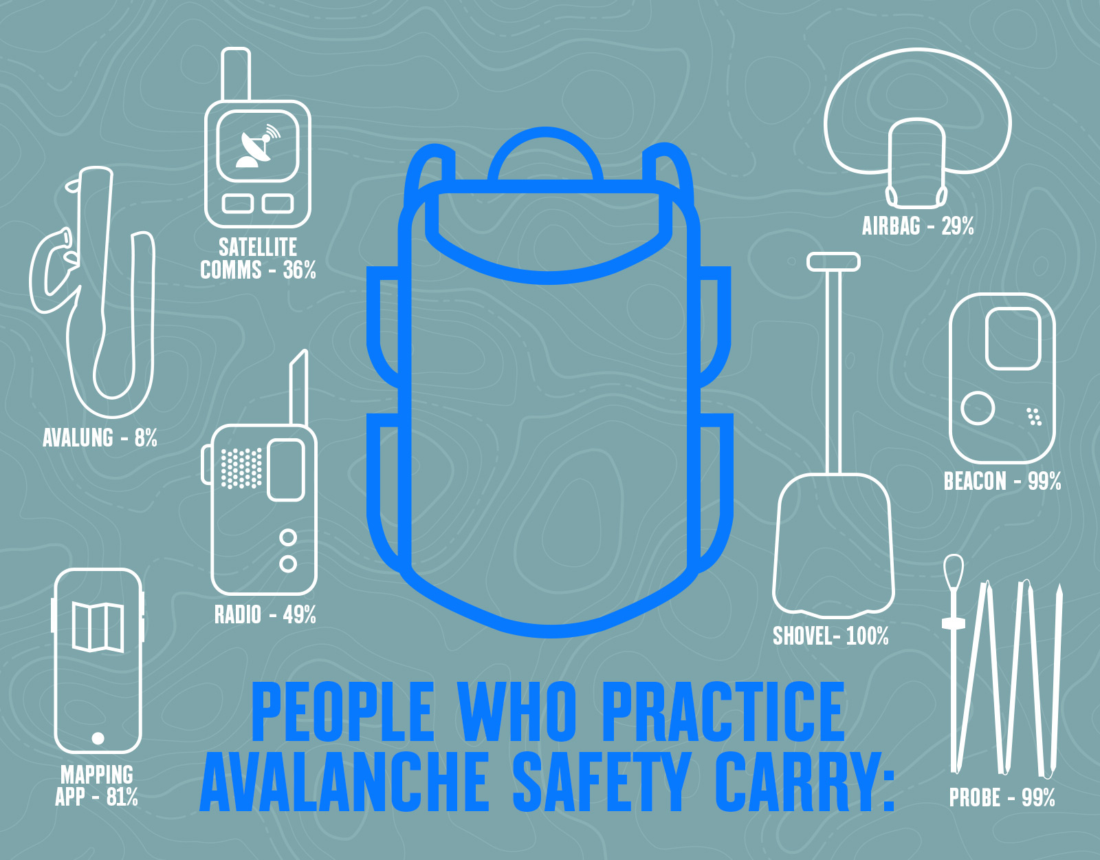
One thing that’s certain across multiple datasets: backcountry travelers (almost) never leave home without a beacon, shovel, and avalanche probe in their packs. Over 99% of respondents in the onX Backcountry survey and 97% in the WEM data confirmed they carry that trio of tools into the backcountry, with almost 30% in the onX survey reporting they also head out with an airbag as part of their kit.
A relatively new development, an avalanche airbags like those available from Backcountry Access, Black Diamond, and Mammut use compressed air to inflate a high-volume airbag to help a skier caught in a slide “float” higher in the debris and improve their chances of avoiding a full burial. Citing a 2014 peer-reviewed study in Europe, the Utah Avalanche Center notes that a deployed airbag can reduce mortality in a slide by 41%.
The onX Backcountry survey delved deeper into users’ packs, with 48% of respondents carrying a radio into the backcountry and 36% taking some kind of satellite communication device. Radios, which rely on line of sight to transmit their signals, offer backcountry travelers a way to communicate with partners through the day and others arriving on the scene during rescue scenarios. Other satellite communications devices, like onX partner Somewear, can keep adventurers in touch after cell service has been left behind.
Know the Forecast, Know Your Partners
onX Backcountry survey respondents placed a high value on one’s own knowledge of conditions in the field, as well as a knowledge of what level of knowledge their partners bring with them into the backcountry—fully 99 percent of survey respondents said they knew how avalanche aware their backcountry partners were.
Around the country, local avalanche centers generate detailed, daily reports of snowpack conditions in their respective zones. These forecast centers are frequently stretched thin and underfunded, but their work is critical to the safety of backcountry travelers and is required reading for those venturing out of bounds.
Some 88% of onX Backcountry respondents reported checking avalanche forecasts each and every time they plan to head into the backcountry and it’s far more than a quick skim: over 50% of those spent between six and 30 minutes taking a deep dive into these forecasts.
“Forecasters pack a lot of information into daily reporting, so it’s important not just to read an avalanche report, think about how it relates to your objective for the day and how it could influence your primary and backup plans,” said onX Backcountry Ambassador and AIARE Lead Instructor Jason Antin. “Slowing down a little at this stage and investing more time pays dividends when you’re out in the mountains putting that information into practice.”
onX Backcountry makes this do-it-every-time check even easier by serving up forecasts within the App right alongside other key inputs to help backcountry users make the safest travel plan possible and adjust to the latest conditions.
Support Your Forecast
To help support the continued service avalanche centers around the country provide, in January 2023, onX Backcountry will donate $4 from each membership purchased through onxmaps.com to avalanche centers across the country.
“Through the support of onX Backcountry users, we can provide additional and better resources to assist with decision making in the backcountry and increase our impact on avalanche safety,” says CAIC Executive Director Aaron Carlson.
Whether you’re checking the daily updates in Taos, Telluride, or Tahoe, your purchase of onX Backcountry in January helps “Support Your Forecast” by helping these organizations fund on-the-ground observations and education for their service areas.
Consider Carrying a GPS Mapping Device
Whether it’s formal avalanche education or the weather forecast, putting as much knowledge as possible in your head is a clear advantage when it comes to backcountry safety. But putting knowledge in your pocket can be just as valuable, as evidenced by over 80 percent of onX survey respondents reporting they use some sort of trail mapping app such as onX Backcountry, Avenza, Caltopo, or Fatmap.
Since nearly everyone is carrying their phone with them anyway, a GPS mapping app is a no-brainer for backcountry travel, especially when paired with features that make it useful beyond cell service (for more than one reason, more on that below). Because GPS uses satellites to triangulate coordination rather than cell towers, a user’s location is reliably displayed deep in the mountains even when line of sight to towers is impossible.
Furthermore, there is some indication that cellular signals can interfere with avalanche beacons when in search mode, so some avalanche centers advise placing cell phones in airplane mode when traveling in the backcountry anyway.
“Several reports from failed or severely disturbed and delayed rescue action in the last years have shown that electronic equipment can have a very unpredictable and severe influence on avalanche rescue transceivers,” according to Utah Avalanche Center Director Mark Staples. “If your cell phone is on, it should be in Airplane Mode to minimize interference.”
Airplane mode doesn’t affect GPS receivers in phones, so you can safely track your location without worrying about electronic interference.
Consider a GPS Mapping App Designed for the Backcountry
If you’re considering adding a GPS mapping app to your arsenal of backcountry travel tools, there are a few features specific to navigating off the grid that can make or break your tour, according to our survey.
Critically, over 90% of onX Backcountry survey respondents rated having avalanche forecast feeds within the app as very valuable—no surprise considering the high value backcountry users place on these reports. And since a key element of avalanche forecasts are safety conditions on a range of slope angles, being able to see slope angle in an app also cleared the 90% mark with respondents identifying very valuable app features. Using a color-coded gradient to highlight slopes from 20° all the way to 45°+, onX Backcountry offers a detailed and easy-to-read overlay to determine the steepness of the terrain.
Around two thirds of respondents keyed in on topographic maps, route navigation tools, and offline capability as very valuable features. Topo maps are a longstanding staple for the clear communication of terrain features at a glance, and navigation tools can help build routes, mark key components of a plan (or Plan B, or C …), and get you back to the truck at the end of the day. But outside of service, it’s Offline Maps, like those offered by onX Backcountry, that can be a make-or-break feature for backcountry users. By downloading a map (and the plan you’ve built on it), users can navigate in the field using GPS (see above) regardless of how far they are from cell service.
3D Maps: Too New to Be Widely Used?
Viewing the landscape in three dimensions is something all backcountry users are well accustomed to … in the field. But on a screen? Perhaps not. Only around 30% of respondents to the onX Backcountry survey keyed in on 3D maps as a valuable tool for their backcountry travels. The technology to deliver high-resolution 3D renderings on any platform is still relatively new—and respondents in this particular survey tended toward more experienced backcountry users—so it’s possible that this newer way of planning and navigating simply hasn’t caught on with an already map-savvy crowd. That said, particularly when it comes to visualizing approaches and potential lines, viewing an area in 3D long before heading out into the field can add a whole new dimension to trip scouting and planning a route.
“3D Maps allow you to scout terrain and very easily see features that could be interesting or problematic, saving you time both in the scouting process and out in the field,” according to pro skier and onX Backcountry Ambassador Griffin Post. “Just another step in making trip planning easier and letting you focus on the adventure at hand rather than logistics.”
In addition to these core features, onX Backcountry offers a few data points that are core to snow season backcountry travelers. A Slope Aspect Layer, available on iOS and desktop with Android coming soon, helps inform what slopes might be more prone to slide because of storm exposure or wind loading, and SNOTEL data from more than 800 stations around the West give near-real-time snow depth and water content data.
GPS App Best Practices
We’ve all done it, pulled a freezing phone out of an outer-layer pocket only to be greeted by a black screen. Batteries and cold temps don’t get along, so a little planning and precautionary packing can go a long way to ensuring your device stays useful for every turn of a long day in the backcountry. A few tips to make the most of your phone’s performance in the field include:
- Start with a full charge and carry a portable battery (also fully charged!) as a backup in case you’re out longer than planned.
- Store your phone in an interior, insulated pocket to help prevent it from getting too cold and draining the battery prematurely.
- Download Offline Maps ahead of time when connected to Wi-Fi so you always know where you are and have your plans in your pocket.
- Once you leave the car or hut, set your phone to airplane mode to conserve battery life.
- If you need to use cell service, make sure you’re in a safe zone on the mountain and remember to flip back to airplane mode before setting back off on your tour.
Key Takeaways
There are all manner of tools you should take with you every time you head into the backcountry, but none is more important than the one between your ears. The experienced backcountry travelers in multiple survey datasets were effectively unanimous in identifying the importance of both avalanche training and always having knowledge of the current conditions via avalanche forecasts.
A beacon, shovel, and probe were also ID’d as the non-negotiable tools in any backcountry traveler’s pack, with more than 99% of our survey participants carrying this trio of mandatory equipment not only for themselves, but for their partners and others recreating in the backcountry.
Finally, using a GPS mapping app designed for touring in the backcountry can consolidate and streamline the knowledge needed by delivering it in a centralized spot, as well as offer a platform for more robust planning before a tour and navigating safely once on the snow.
With the right tools, the right training, and a ceaseless desire to educate yourself on the latest conditions, traveling in the backcountry can be modulated to a range of risk tolerances and experience levels—and trust us, putting in the work is well worth it.