onX Backcountry Expands Winter Tools and Content Coverage in Latest Release
Providing additional information for outdoor adventure in or near avalanche terrain.
onX Backcountry, a navigation and discovery app for outdoor adventurers, expands its winter toolset and content coverage for the 2024-25 season. This update includes a re-vamped slope angle classification tool, 15 additional Avalanche Terrain Exposure Scale (ATES) regions and 5 new expert-curated Guidebook Content ski tour zones. These updates provide backcountry skiers and riders, fat bikers, snowshoers, nordic skiers and other intrepid winter adventurers with information to make safer and more informed decisions in the mountains.
According to Snowsports Industries America’s latest report, winter outdoor recreation participation in the US hit 30M for the first time during the 2023-24 season. While not all of these recreators sought out adventure in avalanche terrain, there are over 4M backcountry skiers and riders, snowshoers, nordic skiers and fat bikers in the Rocky Mountain and Pacific regions who may encounter terrain that could produce an avalanche or be in an avalanche path.
“Many navigation apps today provide tools that tell winter outdoor enthusiasts where not to go, to avoid avalanche risks,” explained onX Backcountry Senior Content Manager Andy Sovick. “At onX Backcountry, we wanted to flip that–and help show where users can go instead of the places to avoid. In conjunction with daily avalanche reports and snow safety education, our goal is to help illustrate what’s possible by rethinking our slope angle classification and by continuing to expand our ATES and Guidebook coverage.”
New Slope Angle Classification: Expanding the Safety Lens
onX Backcountry revamped its Slope Angle Layer, expanding the low-angle shading classification to show slopes steep enough to ski but under the threshold of avalanche activity. Traditionally, “green shading” illustrates slopes between 25-30 degrees. By adjusting that classification to 12-25 degrees, onX Backcountry has helped users find millions more acres of skiable, low-angle terrain with less risk of producing an avalanche.
Expanding ATES Regions: More Regions, More Insight
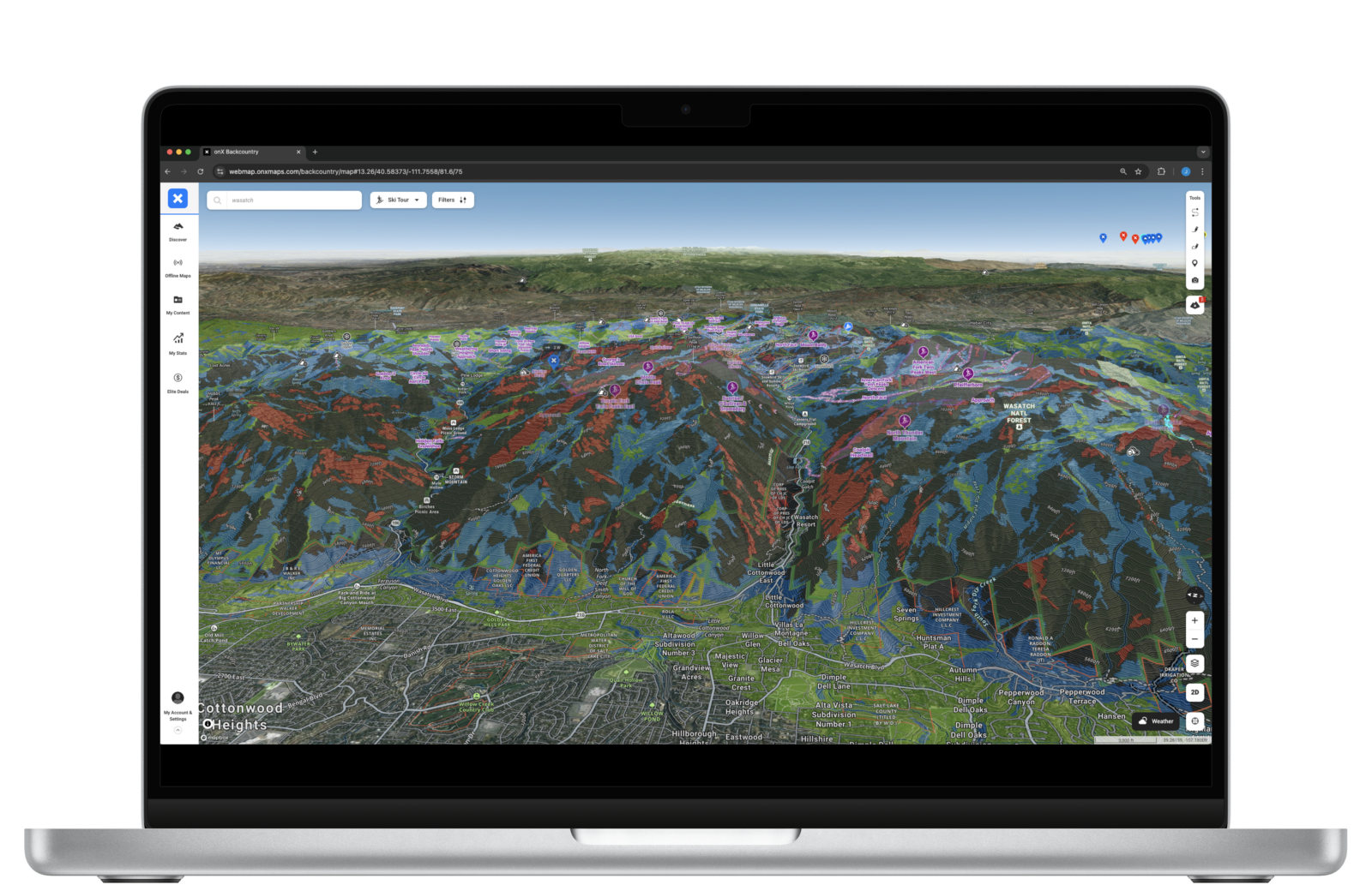
onX Backcountry has also significantly expanded its ATES coverage, mapping avalanche terrain classifications in 15 new regions for a total of 6.9 million acres of mapped terrain across the US.
The ATES system, which is verified in collaboration with local avalanche centers, classifies a region’s terrain based on exposure to avalanches, helping snow enthusiasts–primarily backcountry skiers and snowboarders, as well as fat bikers, nordic skiers and snowshoers–make more informed decisions regarding avalanche safety in the mountains.
Currently, onX Backcountry has 28 total regions mapped, including the new additions:
- Utah: Logan, Ogden, Provo
- Colorado: Rocky Mountain National Park, Cameron Pass, Vail Pass, Buffalo Pass, Summit County (Silverthorne)
- Wyoming: Tetons
- Washington: Snoqualmie Pass, West Slopes North (Baker)
- California: Tahoe through Carson Pass
- Alaska: Turnagain Arm / Girdwood

Avalanche Terrain Exposure Scale (ATES) Layer in the Wasatch Range, Utah
New Guidebook Data
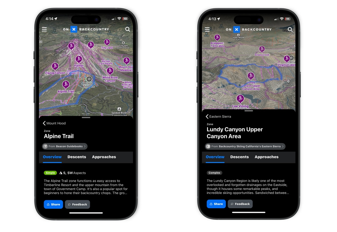
Expert-curated Guidebook Content differentiates onX Backcountry from other apps in the market. With over 1,000 new detailed routes (including approaches, descents and exits, as well as descriptions, photos and elevation profiles) in the zones below, onX Backcountry now has nearly 5,000 curated routes in its Ski Tour Mode. New routes include:
- Peaks and Couloirs of Southwest Montana, compiled by Chris Kussmaul & Kristoffer Erickson
- Backcountry Skiing California’s Eastern Sierra, by Nate Greenberg & Dan Mingori
- Light Tours of Tahoe, by Richard Bothwell
- Backcountry Skiing Taos & Santa Fe, by Marc Beverly
- Backcountry Skiing Mt. Hood, by Eric Schmidgall
Winter enthusiasts can download onX Backcountry at www.onxmaps.com and enjoy a free 7-day trial.

Guidebook Content in Mount Hood and the Eastern Sierra Regions
About onX Backcountry
onX Backcountry empowers trailblazers and adventure seekers of all kinds to find new outdoor experiences and relive old favorites. Unlike other apps on the market, onX Backcountry combines industry-leading GPS tools with expert-curated adventure content. Members can enjoy access to 770K+ trails and over 30,000 guide-book adventures for an annual cost of $29.99. Because off-the-beaten-path experiences are at the heart of what onX does, the company also leads initiatives to protect and expand access to public land and promote stewardship opportunities. Learn more at https://www.onxmaps.com/onx-access-initiatives