Wisconsin Turkey Zone Information & Maps
View In-Depth Information and Detailed Maps for Wisconsin’s Turkey Zones With onX Hunt
It’s no secret that Wisconsin offers excellent turkey hunting throughout the state. As a resident or non-resident, Wisconsin offers affordable tags and tons of opportunity for exceptional turkey hunting.
Wisconsin is divided into seven turkey hunting zones with six different seven-day periods running from mid-April through May that comprise spring turkey season. Each tag issued is only valid for one seven-day period within the overarching season and hunters can purchase numerous turkey tags.
Each year, the Wisconsin Department of Natural Resources (DNR) determines the number of turkey harvest allocations, or tags, that will be available in each zone. Spring turkey harvest allocations are first available through a draw, and then often become available over-the-counter (OTC) beginning mid-March. The application deadline to participate in the draw is in December and allows you to denote which zone and seven-day period you most desire to hunt.
If you want to hunt the early portions of the spring, applying for the draw is paramount. Typically, by the time turkey tags are offered OTC as bonus authorizations, only the tail-end of the season’s seven-day periods will be available.
Here, we break down what to expect in each of the seven Wisconsin turkey zones, and highlight how onX Hunt’s Wisconsin-specific Map Layers can help you plan a successful hunt.
Detailed Information on Wisconsin Turkey Zones
Wisconsin Turkey Hunt Zone 1
Zone 1 Turkey Harvest Statistics
Zone 1 encompasses the entire southwest portion of Wisconsin. According to the Wisconsin DNR, for the fifth year in a row, Zone 1 had the most available harvest authorizations in 2023, with 74,646. The number of available Zone 1 harvest authorizations has held steady for the last several years, with 2022, 2023, and 2024 all offering 74,646.
In Spring 2023, hunters claimed just over 83% of available Zone 1 harvest authorizations, whether through the draw or OTC. Zone 1 hunters harvested 11,737 birds, representing the highest number of birds harvested in any zone, but the fourth-highest success rate at 18.9%. Zone 1’s success rate is up 11.18% year-over-year (2022’s Zone 1 success rate was 17%).
Zone 1 Terrain
Zone 1 is coveted turkey country. Much of the region, known as Wisconsin’s “Driftless Area,” lies along the Mississippi River, the state’s western border. As a result, rivers and creeks dissect the region creating rich habitat. Much of Zone 1 is heavy in agriculture on the tops and bottoms of the area’s hilly and bluffy terrain. Deep draws, coulees, and wooded ridges provide optimal roosting and timber habitat, while agriculture provides ample food for birds throughout the area.
>> See What’s Happening in Wisconsin Turkey Hunt Zone 1
Wisconsin Turkey Hunt Zone 2
Zone 2 Turkey Harvest Statistics
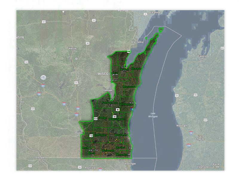
Zone 2 comprises the southeast portion of the state and, much like Zone 1, has no shortage of turkeys. For Spring 2023, the Wisconsin DNR made 51,036 harvest allocations available (the same number this zone saw in 2022 and has available in 2024). Hunters claimed 99.99% of Zone 2 tags and harvested 10,082 birds, representing the highest success rate in any zone at 19.8%, and a 10% year-over-year increase from 2022’s 18% success rate.
Zone 2 Terrain
Zone 2 has far less variable terrain than Zone 1 and is largely agricultural with pockets of timber and marshy vegetation here and there. Birds in this region are highly visible due to the relatively flat terrain—putting in a day of scouting through the windshield can be highly advantageous.
>> See What’s Happening in Wisconsin Turkey Hunt Zone 2
Wisconsin Turkey Hunt Zone 3
Zone 3 Turkey Harvest Statistics
One could argue that Zones 1, 2, and 3 are Wisconsin’s premier turkey zone. This past spring (2023), the Wisconsin DNR reported that Zone 3 saw the second-highest harvest success rate at 19.5% (10,311 harvested birds), a 2.6% year-over-year increase. The Wisconsin DNR sold 83.8% of the 63,018 turkey tags available for Zone 3. Located in the center of the state, Zone 3 is a great place to pick up an extra OTC tag and, for most Wisconsin residents, is just a short drive away.
Zone 3 Terrain
The terrain in Zone 3 is similar to Zone 2. The area features expansive agriculture with blocks of timber that start to become more prevalent the further north you travel. Much like Zone 2, a day spent covering ground in your vehicle can prove advantageous as the generally flat terrain with open crop fields keeps turkeys visible.
>> See What’s Happening in Wisconsin Turkey Hunt Zone 3
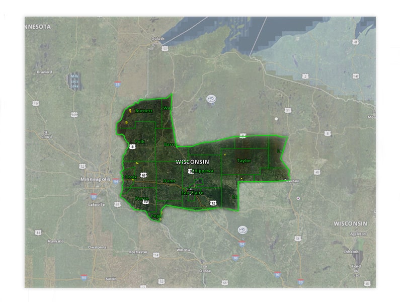
Wisconsin Turkey Hunt Zone 4
Zone 4 Turkey Harvest Statistics
Zone 4 lies in north-central Wisconsin and extends to the state’s western border. Hunter numbers for the northern zones drop off drastically starting in Zone 4. For the 2023 spring season, the Wisconsin DNR sold 99.99% of the available 34,968 turkey harvest authorizations. Hunters in Zone 4 harvested 6,629 birds for a 19% success rate (a 5.56% year-over-year increase).
With fewer hunters than the more premier southern turkey zones but still excellent bird numbers, Zone 4 is a good option for hunters seeking a little solitude.
Zone 4 Terrain
The landscape in Zone 4 begins to transition from largely agricultural to large swaths of unbroken timber. As you move west, you will find more variable terrain as you get closer to the St. Croix and Mississippi Rivers, where deep ravines and bluffs become common.
>> See What’s Happening in Wisconsin Turkey Hunt Zone 4
Wisconsin Turkey Hunt Zone 5
Zone 5 Turkey Harvest Statistics
Zone 5 lies in the northeast corner of the state and borders Michigan’s Upper Peninsula. Zones 5, 6, and 7 see a notable drop-off in total hunter numbers as the northernmost parts of Wisconsin are not traditional “turkey country.” In Spring 2023, Zone 5 had 12,000 harvest authorizations available and sold 11,998. Hunters in Zone 5 experienced a 16.2% success rate, harvesting 1,944 birds. This is an improvement over 2022’s 14% success rate in Zone 5, but still under the 18.2% success rate seen as recently as 2020.
Zone 5 Terrain
Zone 5 consists largely of vast swaths of timber with scattered agricultural areas. Given this, Zone 5 has chunks of public ground that may not look like traditional turkey habitat but still hold a fair share of birds. Putting boots on the ground and using your ears to find turkeys will be key to getting on birds in this zone.
>> See What’s Happening in Wisconsin Turkey Hunt Zone 5
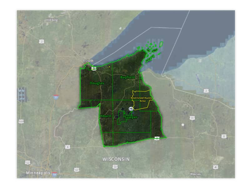
Wisconsin Turkey Hunt Zone 6
Zone 6 Turkey Harvest Statistics
Zone 6 was the only area where the number of harvest authorizations changed from 2022 to 2023. In 2022, the Wisconsin DNR authorized 5,400 tags, whereas 2023 saw 6,000 harvest authorizations. Wisconsin’s Zone 6 harvest allocations frequently sell out during the draw, with no tags available OTC, and 2023 was no exception. Of the 6,000 harvest authorizations distributed, 1,101 were filled, for an 18.3% success rate—just a slight increase over 2022’s 18% success rate.
Zone 6 Terrain
Zone 6 stretches north to the southern edge of Lake Superior. This part of Wisconsin is known for its strong tradition of gun deer season. For those unfamiliar with the area, large swaths of hardwoods make for difficult hunting. Turkeys are not very visible given the topography, and hunters have to work hard to get on birds.
>> See What’s Happening in Wisconsin Turkey Hunt Zone 6
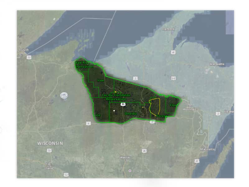
Wisconsin Turkey Hunt Zone 7
Zone 7 Turkey Harvest Statistics
Zone 7 forms much of Wisconsin’s border with Michigan’s Upper Peninsula in the north-central part of the state. All 4,400 spring turkey hunt authorizations released by the Wisconsin DNR were spoken for in Spring 2023. Hunters harvested 545 birds, giving Zone 7 the lowest harvest success rate at 12.4%. Still, that’s a slight uptick from 2022’s 12% success rate.
Zone 7 Terrain
Just like Zone 6, Zone 7 will be a difficult turkey hunt if you are unfamiliar with the area. Birds are tough to find since the zone is composed almost entirely of expansive timber. Focusing on public and private edges will likely be one of the best tactics, as much of the food turkeys depend on will be found on private lands. If you are looking for a challenging turkey hunt in non-traditional turkey country, this is your zone.
>> See What’s Happening in Wisconsin Turkey Hunt Zone 7
How To View Wisconsin Turkey Hunting Zones
Thinking of taking to Wisconsin’s spring turkey woods? From e-scouting on our Web Map and downloading Offline Maps at home to navigating boundary lines and knocking on doors for permission, onX Hunt has you covered.
onX Web Map
Using Web Map to e-scout is one of the most underutilized features of onX Hunt. The importance of preparing in advance for upcoming hunts cannot be overstated, and onX Hunt makes it easy.
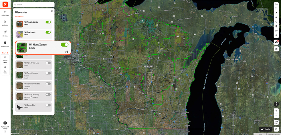
If you’re on a desktop or laptop computer and have an account with onX, click here to login. If you don’t have an account, click here to start a free trial. Once logged in, click “Hunt Map Layers” at the top of your screen. If Wisconsin is not displayed under your “Map Layers,” simply scroll down to toggle the state on.
From there, you will find several Wisconsin-specific Map Layers to help you plan your hunt, including “WI Hunt Zones.” Click on “Details” and toggle the “Turkey” layer on. Now, you can pan over Wisconsin and click into any zone that interests you. When you click into a zone, you can access more information about a unit, the weather for that area, current regulations, and more.
onX Hunt App
If you’re on a mobile device and don’t have the onX Hunt App, click the “Get the App” button in the upper right-hand of your screen. After you’ve downloaded the onX Hunt App from the App Store or Google Play, turn on Wisconsin Turkey Zones by opening the Hunt App and tapping on “Hunt Map Layers” in the bottom-left corner. If Wisconsin does not appear toward the top of your “Map Layers,” simply scroll down to “Wisconsin” and tap the toggle.
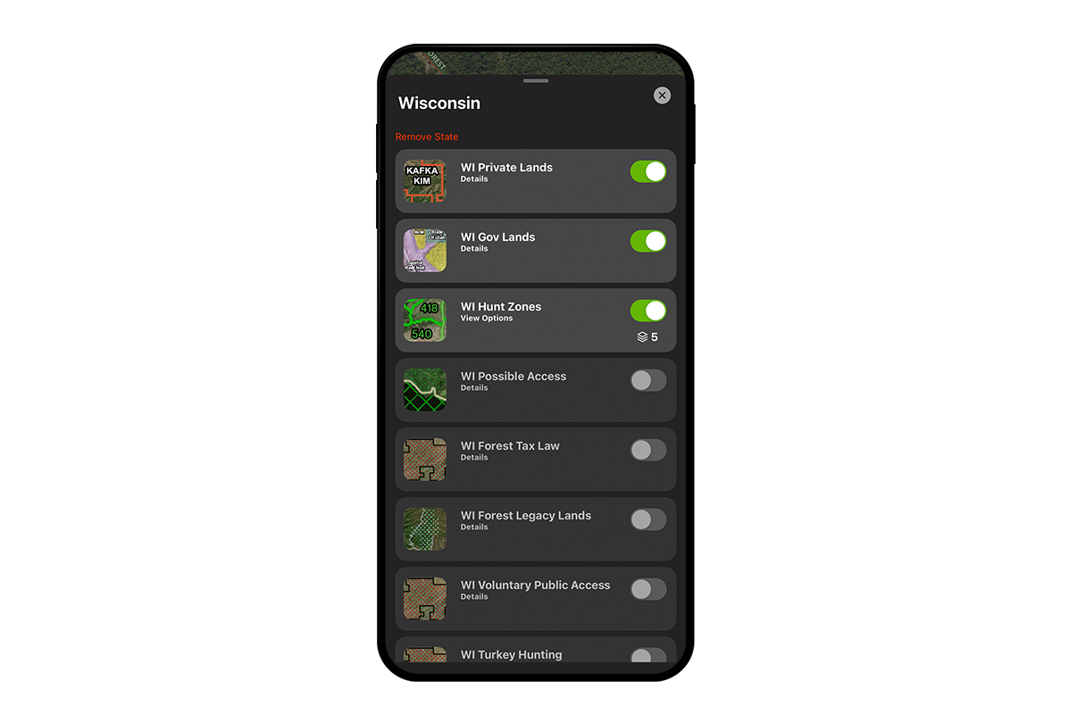
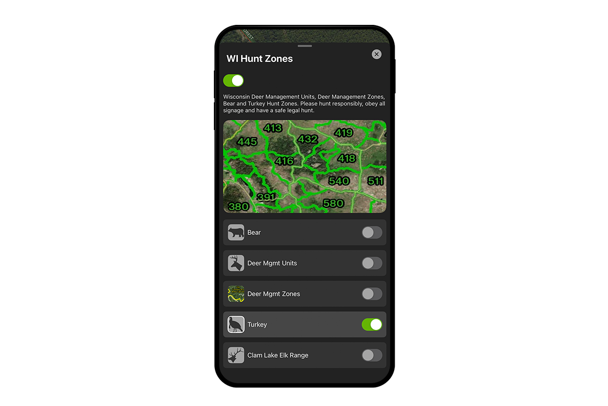
Now, back at the top of “Map Layers,” tap on Wisconsin to open the state-specific layers. Tap the toggle next to “WI Hunt Zones” and tap “Details” to toggle “Turkey” on. You will now see the seven WI Turkey Zones outlined in green throughout the state. When you tap on a zone, you can access more information about a unit, the weather for that area, current regulations, and more.
Other Wisconsin Map Layers for Your Turkey Hunt
In addition to WI Hunt Zones, WI Gov Lands, and WI Private Lands, onX Hunt offers several other Map Layers you may find helpful when planning your turkey hunts. Wisconsin manages several programs that open up private land and other possible access points at certain times throughout the year. onX Hunt aggregates this information into Map Layers to help you find additional access opportunities.
- WI Possible Access: This Map Layer shows approximately 660,000 acres of possible access throughout the state, made available by entities such as timber companies and conservation groups.
- WI Forest Tax Law: This Map Layer shows land open to hunters under the Forest Tax and Forest Managed Law Programs.
- WI Forest Legacy Lands: This Map Layer shows areas protected through the Forest Legacy Program, which is designed to help ensure public access while the property remains in private ownership.
- WI Voluntary Public Access: This Map Layer shows land open to hunters under the Voluntary Public Access and Habitat Incentive Program (VPA-HIP), which incentivizes private landowners to allow recreational activities like hunting on their properties.
- WI Turkey Hunting Access Program: This Map Layer shows land open specifically to spring turkey hunters from March 1 – May 29 under the Turkey Hunting Access Program (THAP).
Conclusion
Wisconsin is one of the premier turkey hunting states in the Midwest and could arguably compete as one of the top states in the country. With generous spring license allocations, reasonable season splits, and plenty of longbeards, it’s time to go get yourself a Wisconsin Eastern. And, with onX Hunt’s turkey-specific Map Layers, you can take the guesswork out of scouting and feel more confident in the the field.


