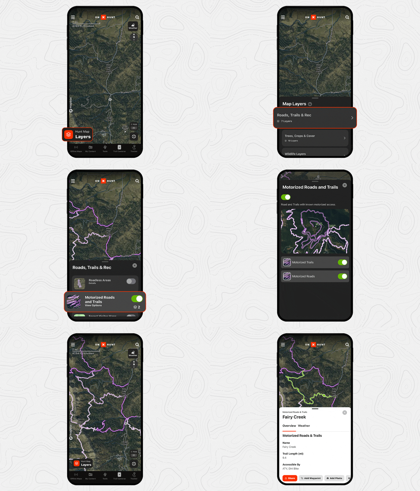
Discovering the best driving route to your hunting grounds is nearly as important as finding your way once you’re hoofing it in the backcountry. The onX Hunt App includes a nationwide map of highways, roads, streets, back roads, forest service roads, two-tracks, and dirt roads to help you locate the best routes and access points for your hunt.
onX Hunt Motorized Roads and Trails
onX’s road data is gathered from a variety of federal, state, and county databases. For example, in addition to including many smaller sources, we aggregate United States Forest Service (USFS) data, which involves approximately 380,000 miles of roads and trails, as well as Bureau of Land Management (BLM) data, which includes another 90,000 miles. While much of the land managed by government entities is prime for hunting, the routes to access those lands vary greatly in accessibility and maintenance.
To make it easy to research road and trail status and stitch together your preferred route, onX Hunt consolidates relevant information within the “Motorized Roads and Trails” Map Layers under “Roads, Trails, and Rec.” With these Map Layers turned on, when you select a road or trail, you’ll see at-a-glance details, including:
- The name of the road or trail.
- The length of the road or trail.
- The vehicle class(es) that can access the road or trail.
- The surface type (e.g. natural, gravel, dirt, etc.).
- The dates the road or trail is open (if applicable, broken down by various vehicle classes).
- The entity that manages the road or trail.

onX Hunt Roads and Trails Legend
When you turn on the Motorized Roads and Trails Map Layer and zoom to an area with forest roads, you’ll notice several variations of purple lines. Here’s what they mean:
- Solid purple: The road should be accessible to any highway-legal vehicle (i.e., overland).
- Solid purple with hash marks: The road should be accessible to high-clearance 4×4 vehicles and side-by-sides.
- Long purple and white dashes: The road or trail should be accessible by ATVs.
- Short purple and white dashes: The trail should be accessible by dirt bikes.
Conditions can vary depending on maintenance resources, seasons, usage, and weather, so always prepare alternative routes.
Public vs. Private Roads
It can be difficult to establish whether or not a road is public or private, and no comprehensive, reliable database exists for easy reference. Additionally, regulations can differ from state to state, county to county, and even from one property to another. Some private properties may have right-of-way agreements or easements allowing public road use whereas others do not. Usually, this is up to the property owner, and the only way to know before getting there is to contact the local government or the landowner directly.

Plan Your Route
Once you’ve picked your hunting spot, it’s time to consider the best access road(s) to use. There are many ways to plan your route in the Hunt App, from eyeballing it to using the Line Distance Tool. However, if you’re a Premium or an Elite Member, two onX features, Route Builder and In-Dash, make researching and navigating the route to your hunting spot the easiest part of your season.
Route Builder
Available to Elite Members, Route Builder does exactly what its name promises. To access this feature, tap “Tools” and “Build Route.” From there, you can choose to “Point Draw” your route if you prefer to create your path of travel manually, or you can select “Snap To” to have the Hunt App do the work for you. When you have “Snap To” selected and you begin tapping from one point to another on the map, Route Builder will automatically select the best route between the two points.
As you build your route, you’ll be able to see its distance, elevation gain, and elevation loss. You can also customize the route color and line style as well as add notes. When you save the route, you can access it by tapping it on the map or by finding it under “My Content.”
Check out the video below to see Route Builder in action.
In-Dash
Available to Premium, Premium Two-State, and Elite Members, In-Dash allows you to display your onX Hunt Routes, Maps, Waypoints, and more on any vehicle that accommodates Apple CarPlay or Android Auto.
Watch the video below to see how In-Dash provides you with real-time, in-the-field insights.
Check all portions of your planned route, looking for areas that may be blocked at certain times of year, or roads that go through private property and may be closed. That way, you won’t find yourself detouring for hundreds of miles around a locked gate or impassable snowdrift. The best route to your destination is not necessarily the shortest, it’s the one that’s been thoroughly researched and scouted.