Bridger Ridge
Total Miles
5.2
Technical Rating
Best Time
Summer, Fall
Trail Type
Single Track
Accessible By
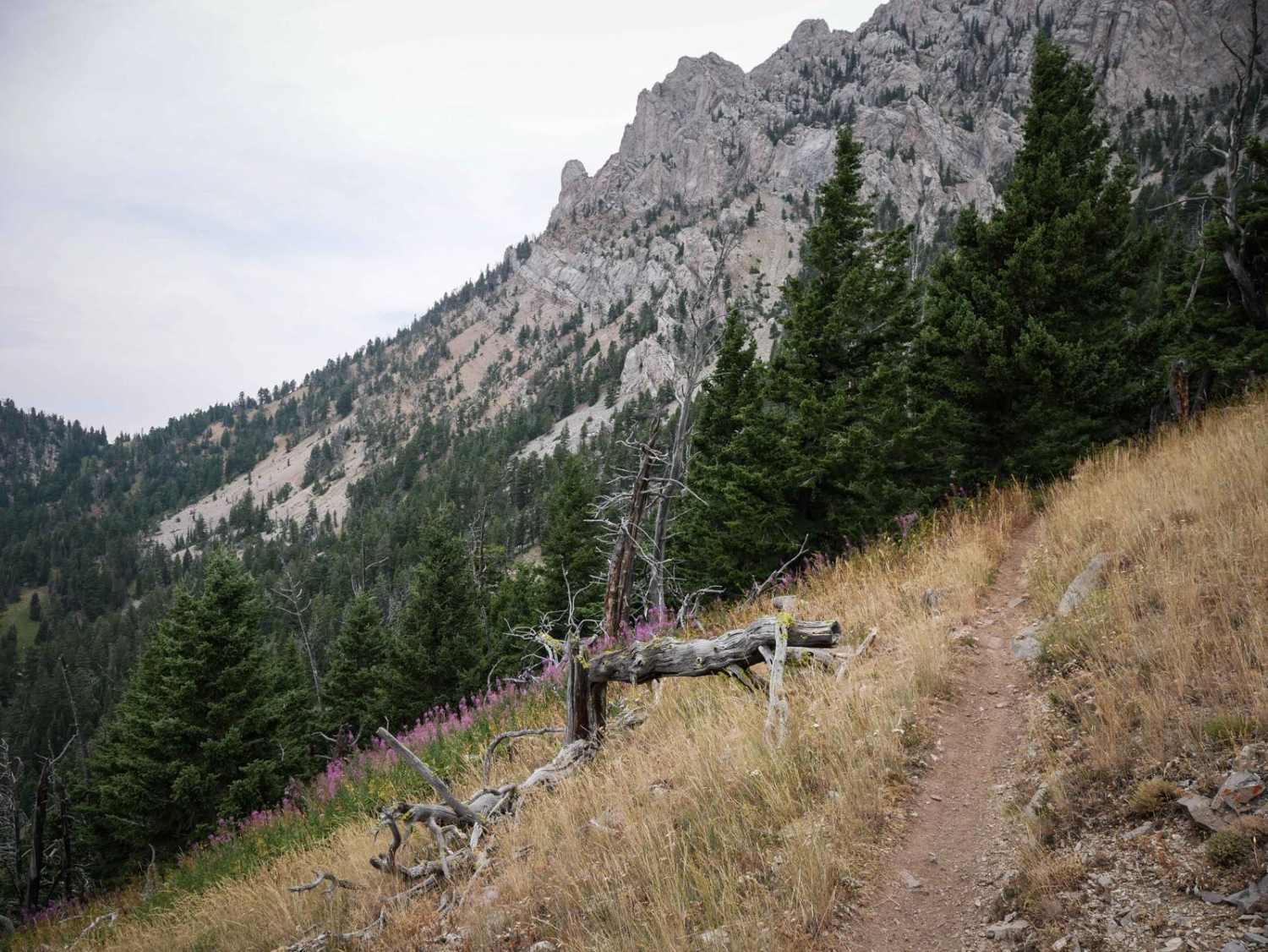
Trail Overview
Bridger Ridge is a top-tier single track in Montana's Bridger Mountain Range. It's full of incredible views and technical challenges and is mostly an epic skinny trail atop a ridge line around 8,000 feet elevation. It starts at the top of Ross Pass at the intersection with Upper Brackett Creek. It's super narrow the whole way, especially as it side-hills across exposed steep mountain slopes, and crosses several scree fields. Some of the scree is flat and easy to cross, but other sections have more jagged embedded boulders, creating rock pinches and small obstacles you have to ride over. There are rock outcroppings lining the trail too, encroaching over the trail and making it even narrower. There are lots of steep spots throughout the trail, and very exposed hillsides, which make it more technical, but are really scenic and unique, as you feel like you are in the high alpine. When you're on top of the ridge line you get great views of the Bridger Range and look down the mountain valleys. There is a series of downhill switchbacks in the first half of the trail that are very steep and tight. The average rider won't be making it fluidly down the switchback; it'll require multiple point turns or even getting off your bike to walk it down. One of the switchbacks comes up really quick behind a tree, and you can see where riders have blown off the trail, but luckily there's not a drop-off at that one. After that, the trail gets a bit rockier during a shelfy section, where there are choppy embedded layers of rock across the trail. Near the end, there are several uphill switchbacks that are just as tight and technical. One of them has layers of rock that create a small ledge on the inside corner, making it more challenging. There is some extreme exposure near the north end of the trail, as the narrow trail continues to switch back up to the intersection with Corbly. This trail is a local favorite, and you'll likely see other riders. The trail is really well maintained, and not blown out, so please try to keep it that way.
Photos of Bridger Ridge

Difficulty
The advanced difficulty comes from the extreme narrowness, exposure, and lots of technical tight switchbacks. The trail is 6 inches wide at times. There aren't huge ledges or crazy steep hill climbs on this trail, but riders need to be able to navigate the extremely narrow trail with good balance and control. Don't let that rear tire drop down the edge of the trail.
Bridger Ridge can be accessed by the following ride types:
- Dirt Bike
Bridger Ridge Map
Popular Trails
Beaver Creek Trailhead
Cottonwood Lakes

BLM 9 (Dry Creek Single Track)
The onX Offroad Difference
onX Offroad combines trail photos, descriptions, difficulty ratings, width restrictions, seasonality, and more in a user-friendly interface. Available on all devices, with offline access and full compatibility with CarPlay and Android Auto. Discover what you’re missing today!