Moki Dugway - UT Highway 261
Total Miles
2.7
Technical Rating
Best Time
Spring, Summer, Fall, Winter
Trail Type
Full-Width Road
Accessible By
Trail Overview
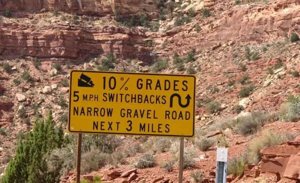
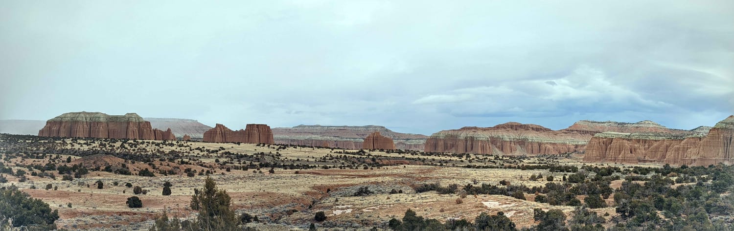
The Moki Dugway is a 2.7-mile unpaved stretch of Utah State Highway 261. What makes this unusual is this section of road was created by carving into the cliff walls and has remained unpaved since it was created in the 1950s. This is also listed as one of the most dangerous roads in America. The Moki Dugway is a section of gravel road featuring 10% grades and steep hairpin switchbacks straight up the thousand-foot cliff wall of Cedar Mesa. The elevation difference between the top and bottom of the dugway is 1000'. From the parking area near the top of the dugway, the panoramic view is amazing offering views into three different states. Major land features that can be seen are the Valley of the Gods directly east, further east the Sleeping Ute Mountain in Colorado is also visible. Shiprock New Mexico is visible to the southeast. The road is mostly gravel with a couple of the turns being broken blacktop. The road is generally two vehicles wide allowing for careful passing of vehicles in opposite directions. The speed limit within the dugway is 15 miles per hour with many of the turns advised at 5 miles per hour. This winding road is rooted firmly in the mid-20th century's nuclear age. The Moki Dugway was constructed in the 1950s by the Texas Zinc mining company, and it was initially used to transport uranium ore from the Fry Canyon mines to a processing mill near Mexican Hat. While Moki Dugway may seem like a really strange name, it actually makes sense when you know the full story. The name Moki comes from a misspelling of the Spanish word Moqui which Spanish explorers used to describe the Puebloan people inhabiting the area. Today it's a significant insult to refer to a Puebloan as a Moki or Moqui. A dugway is a road constructed along a hillside by using the fill from the uphill side to construct the road on the downhill side. Essentially carving into the cliff or hillside. There is no cell service in the area. The nearest service which is minimal is located in Mexican Hat about 10 miles south of the dugway. Heading north the nearest towns of note are Blanding, 50 miles to the northeast, and Hanksville, 115 miles to the north.
Photos of Moki Dugway - UT Highway 261

Difficulty
This is a county dirt road maintained for high clearance 2WD and 4WD use in adverse conditions. There are steep grades that may be impassable in winter.
Status Reports
Moki Dugway - UT Highway 261 can be accessed by the following ride types:
- High-Clearance 4x4
- SUV
- SxS (60")
- ATV (50")
- Dirt Bike
Moki Dugway - UT Highway 261 Map
Popular Trails
Sevier River North Overlook

Strawberry Ridge - FR 70135
Unforgiven
The onX Offroad Difference
onX Offroad combines trail photos, descriptions, difficulty ratings, width restrictions, seasonality, and more in a user-friendly interface. Available on all devices, with offline access and full compatibility with CarPlay and Android Auto. Discover what you’re missing today!