Pivot Rock Canyon
Total Miles
5.5
Technical Rating
Best Time
Spring, Summer, Fall
Trail Type
Full-Width Road
Accessible By
Trail Overview
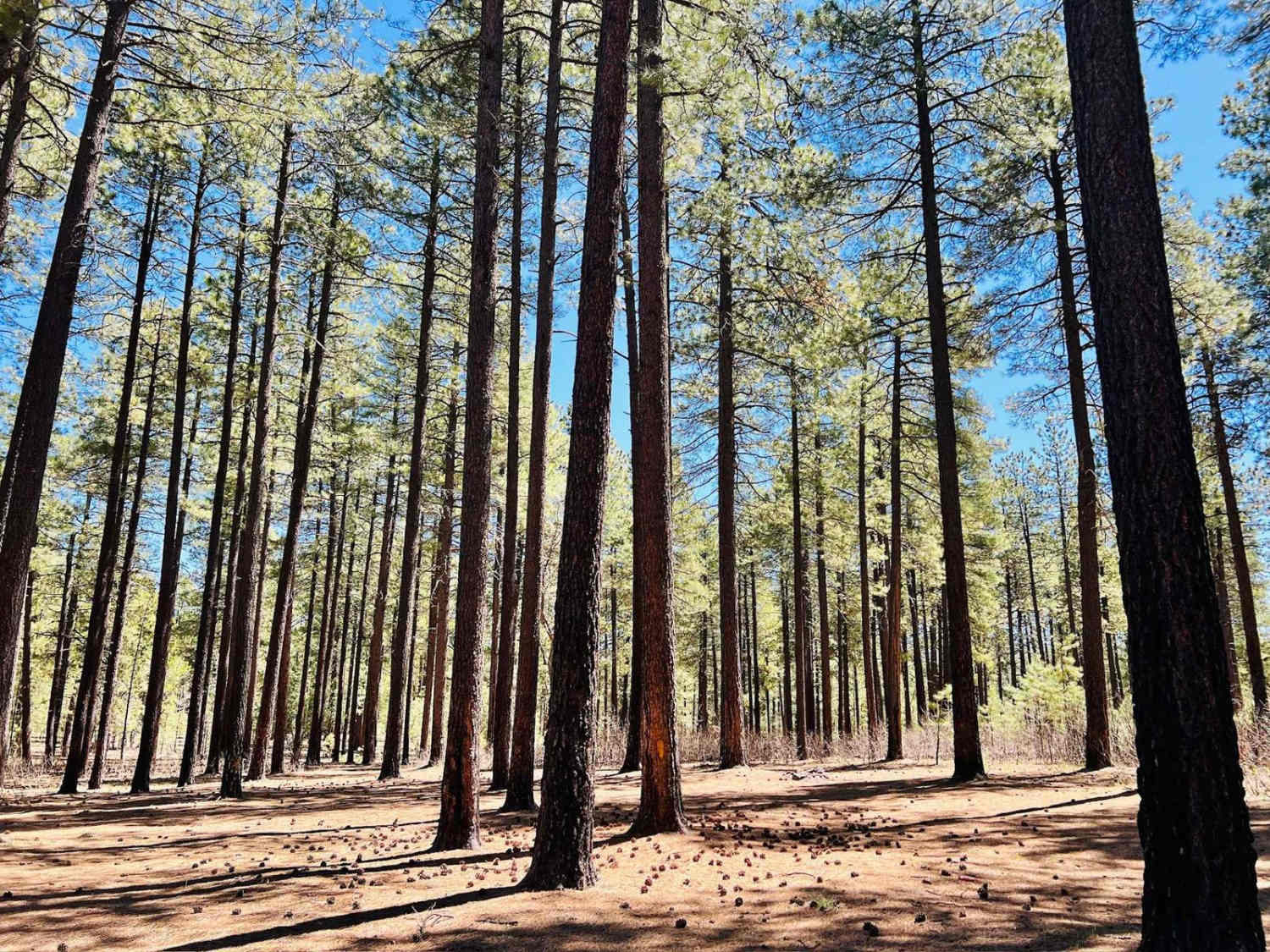
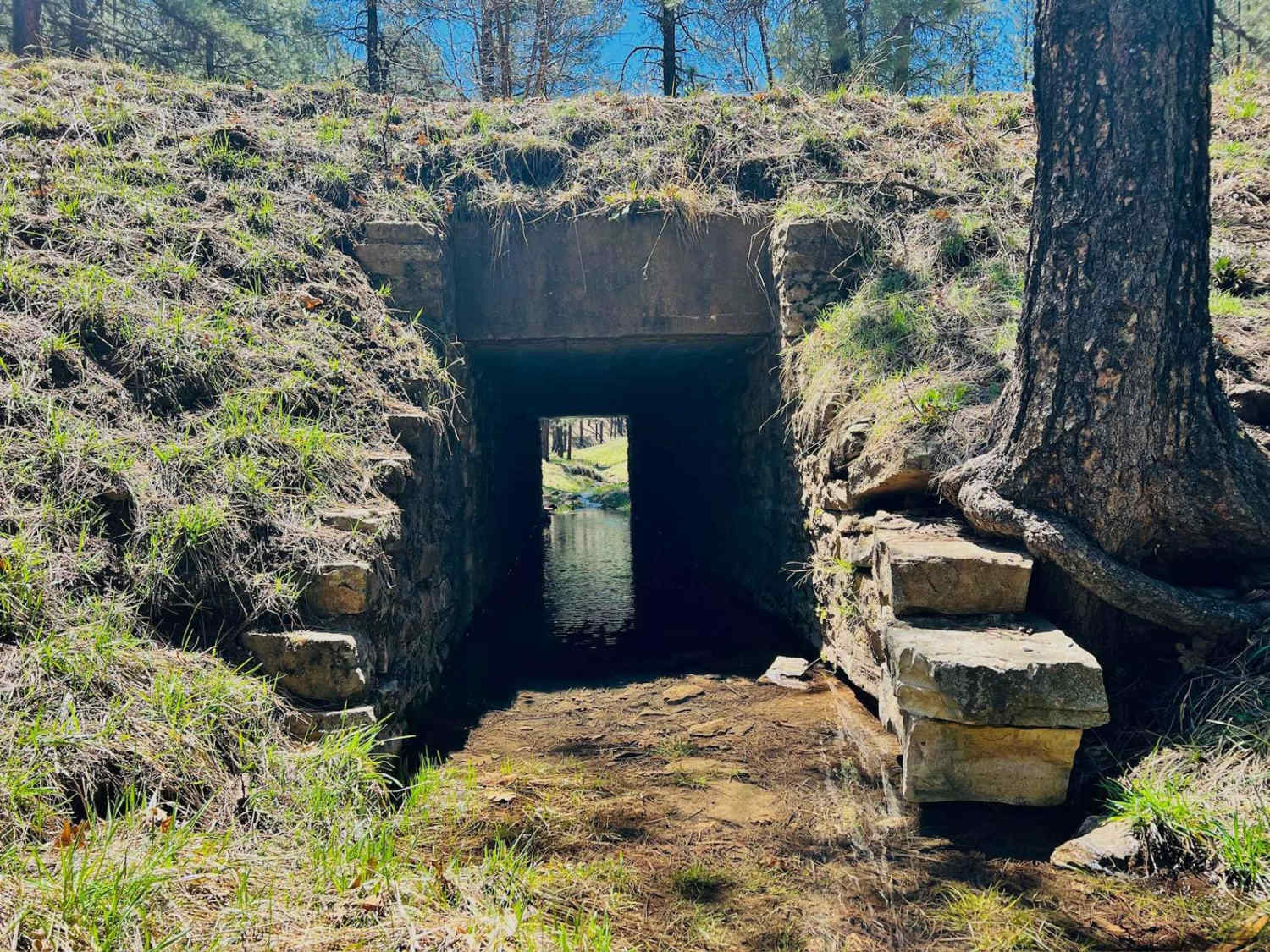
This is a lovely, mostly graded dirt road that connects from Highway 89 over to the Hicks/Duncan Trail. There are a plethora of large open flat campsites to choose from, particularly on either end of the trail. This would be easy access for larger vehicles with trailers and motorhomes. The Pivot Rock Canyon is about the midpoint of the trail. It twists and turns back and forth along a ridge with a couple of canyons next to it and drops down into the Pivot Rock Canyon. There is a stream running through with a little bridge. There is camping down in this area. It can be seen from the main trail; however, if you are looking for a campsite with less traffic, you will need to dig a little deeper. A couple of other trails meet up with this one, allowing access to a network of different trails in the area. The trail is lined with tall pines on either side that keep this area cool and shade several campsites. There are also open grassy areas in the springtime.
Photos of Pivot Rock Canyon
Difficulty
This well-maintained dirt trail shows signs of regular grading. A few slightly narrow spots make passing oncoming traffic a little trickier. However, this road is generally quite wide. A few rocks in some of the twists make the trail surface a little bumpy.
History
The Mogollon Rim is a rugged escarpment that forms the southern limit of the Colorado Plateau. It extends across the entire forest, approximately 200 miles in total, and provides excellent views within plateau country and desert canyon country as well. Dropping as much as 2,000 feet in some areas, the Rim offers some of the most far-reaching scenery in Arizona. Views stretch from its rocky precipice to Four Peaks of the Mazatzals northeast of Phoenix. Sightseeing is a favorite activity along the Rim. Still, this forest area also boasts a historic system of hiking and horseback trails, a couple of picturesque lakes for boating and fishing, and backcountry skiing for wilderness adventurers. The Mogollon Rim is a topographical and geological feature cutting across the northern half of Arizona. It extends diagonally approximately 200 miles, starting in northern Yavapai County and running eastward, ending near the New Mexico border. It forms the southern edge of the Colorado Plateau in Arizona. The Rim is an escarpment defining the southwestern edge of the Colorado Plateau. Its central and most spectacular portions are characterized by high cliffs of limestone and sand, namely the Kaibab limestone and Coconino sandstone cliffs. This escarpment was created by erosion, faulting, and cutting dramatic canyons into it, including the Fossil Creek Canyon and Pine Canyon. The name Mogollon comes from Don Juan Ignacio Flores Mogollon, the Spanish governor of New Mexico from 1712 to 1715. The Mogollon Rim's limestones and sandstones were formed from sediments deposited in the Carboniferous and Permian Periods. Several of the Rim's rock formations are also seen on the walls of the Grand Canyon. The extensive basaltic lava flows cap or even bury the Rim in many places. Be sure to keep your eyes peeled for the endangered Mexican spotted owl. Other wildlife present on the Rim will be herds of elk and deer. You may see black bears, mountain lions, and even the occasional red-tailed hawk or peregrine falcon. There are also coyotes, horned toads, and rattlesnakes. This area frequently has fire restrictions early in the season. Be sure to contact the local ranger station for information about the current campfire restrictions. Or, at the minimum, check the Coconino Fire webpage. https://www.coconino.az.gov/2595/Fire-Restriction-Information
Status Reports
Pivot Rock Canyon can be accessed by the following ride types:
- High-Clearance 4x4
- SUV
- SxS (60")
- ATV (50")
- Dirt Bike
Pivot Rock Canyon Map
Popular Trails

Bob E. Tank / 164

Vekol Wash I-8 Bridge Crossing
Oak Creek Cabin
Benchmark Mountain
The onX Offroad Difference
onX Offroad combines trail photos, descriptions, difficulty ratings, width restrictions, seasonality, and more in a user-friendly interface. Available on all devices, with offline access and full compatibility with CarPlay and Android Auto. Discover what you’re missing today!